The journey to explore the tourist route connecting Dong Van Karst Plateau Geopark (Ha Giang) with Non Nuoc Cao Bang Geopark will bring visitors memorable experiences about the land and people of the locality. Head of the Fatherland.
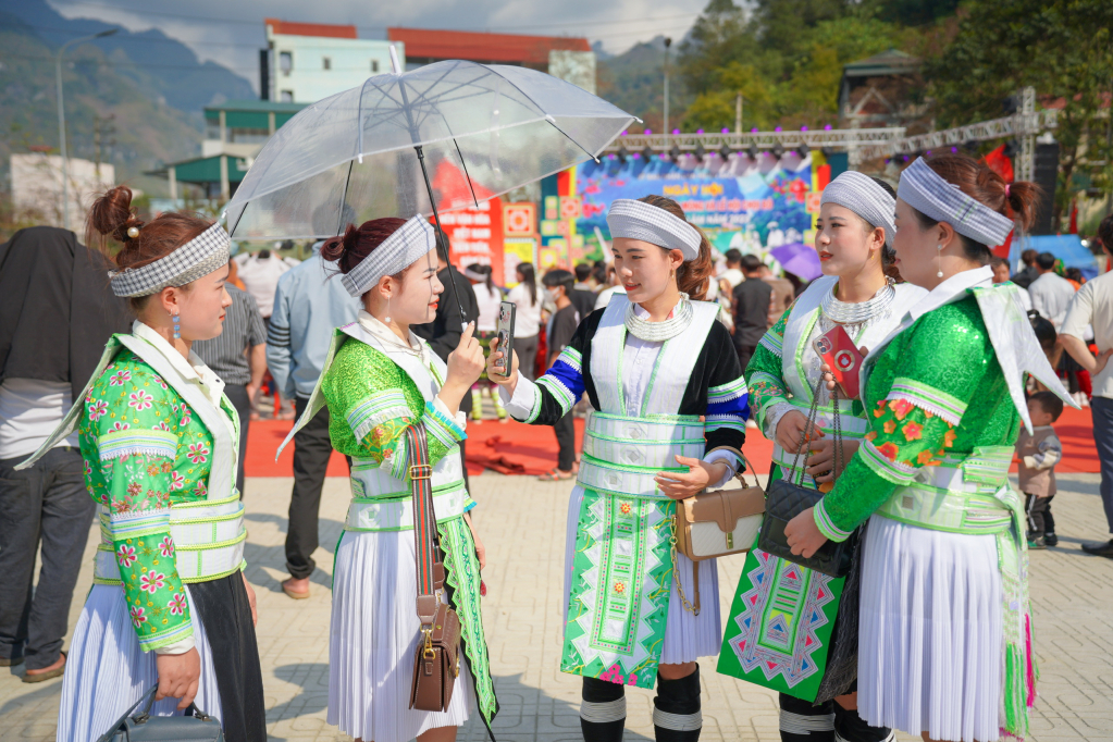
Located at an average altitude of 1,000 – 1,600 m above sea level, Dong Van Karst Plateau Geopark has a total area of 2,356 km2 with nearly 140 heritage sites. The terrain is rugged and sharply divided with sharp rocky mountains, deep and narrow ravines, towering cliffs, and mountain peaks like pyramids. This is where 17 ethnic groups live: Mong, Pu Peo, Lo Lo, Nung, Hoa… Experiencing ups and downs, events of history and development in all aspects of society, people of all ethnic groups The rocky plateau tribe still maintains its own identity with many unique and charming features.
With an area of more than 3,683 km2, Non Nuoc Cao Bang Geopark is a testament to the earth’s complex geological development history spanning more than 500 million years. This land has over 130 geological heritage sites with rich and diverse terrain types and limestone landscapes such as: stone towers, cones, valleys, caves, river and lake systems, underground caves… reflecting a Complete cycle of karst evolution in the northern tropics of Vietnam.
Nature has endowed Non Nuoc Cao Bang with many majestic and poetic landscapes, ecosystems, and endemic species of animals and plants. This place is also the cradle of revolution with many “red addresses” such as the Pac Bo Special National Relic Area (Ha Quang), Tran Hung Dao forest (Nguyen Binh), the site of the 1950 Border Victory (Thach An)… In addition, the province has more than 200 relics and more than 2,000 tangible and intangible cultural heritages. Indigenous culture is prominently expressed in the daily life, customs, beliefs, and festivals of the Tay, Nung, Mong, Dao, San Chi, Lo Lo ethnic communities…
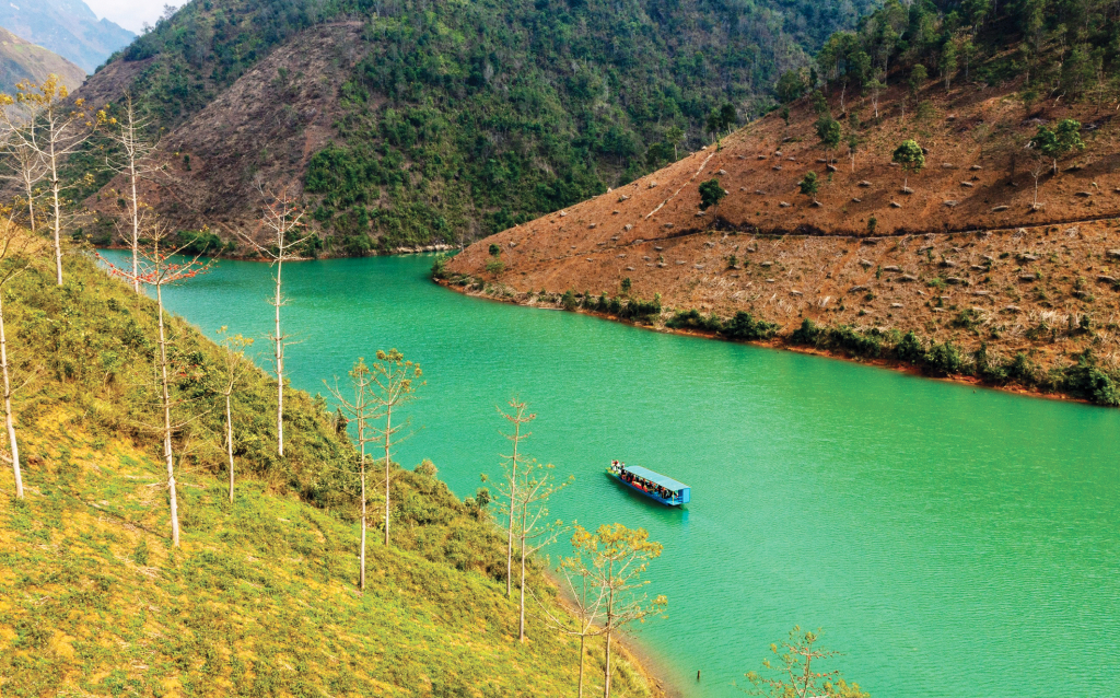
The Dong Van Karst Plateau Geopark – Non Nuoc Cao Bang Geopark route is a great travel itinerary for those who are passionate about traveling, want to immerse themselves in nature, and experience the life of the copper. highland area. Coming to Meo Vac district (Ha Giang), visitors can check in at the Ma Pi Leng pass stop, see the Tu San canyon on the Nho Que river, visit the Monument of Youth Volunteers to Open the Road to Happiness, and participate in the ceremony. buckwheat flower festival… From Meo Vac town going west along Highway 4C, don’t miss the opportunity to experience a cruise on the lake of Bao Lam 3 Hydropower Plant, enjoy the beauty of Phong Luu alley, Bat cave , terraced fields in the golden rice season and bright red rice flowers around the lake… Touch the ground of Ly Bon commune (Bao Lam), visit Lung Lon cave (Nang Tien cave), explore the landscape of Khuoi Vin, Tong Ac… Then enter Highway 34 to Bao Lac district.
Along the romantic Gam and Neo rivers, the mysterious and enchanting beauty of Bao Lac’s land, culture and people captivates people’s hearts. Prime river position, rolling mountain position, charming natural scenery with beautiful landscapes such as: Phja Da (Son Lap commune) 1,987 m high above sea level – considered the “roof” of As tall as; Khau Coc Cha Pass with 15 winding and dangerous floors, Thom Lom Lake (Xuan Truong); Bao Toan commune hydroelectric lake; Ho Nhay slot (Co Ba)… Immersed in the atmosphere of Bao Lac market, visitors can learn about local culture, customs and enjoy delicious specialties that will make their journey more enjoyable. Interesting, meaningful part.
From Bao Lac town, you can choose 2 routes to explore the Northern and Western routes of Non Nuoc Cao Bang Geopark. Cross Khau Coc Cha Pass (Xuan Truong commune) and enter Highway 4A along the border belt to Ha Quang district to the Northern cluster tourist route “Journey to the roots”, learn about the land with many values Cultural and historical heritage representing the tradition of fighting to defend the country and protect the independence and freedom of the nation such as: Pac Bo Special National Relic Area, Kim Dong Historical Relic Area (Ha Quang) ; King Le Temple, De Doong Temple (Hoa An)… Visit Keo Yen landscape, Soc Giang hanging valley, Lung Luong chrysanthemum or Luong Noi brocade weaving village, Ban paper craft village, Na Keo herb incense village (Hanoi). Quang)…
In addition, tourists choose to follow Highway 34 to Nguyen Binh district with the western cluster tourist route “Exploring Phja Oac – the mountainous region of changes”. The highlight of this route is the Phja Oac – Phja Den eco-tourism area with the 1,931 m high Phja Oac peak covered with clouds all year round. Visitors will be able to visit geological relics that show that this mountainous area was once an ocean about 400 million years ago. High mountain terrain creates different climate sub-zones from the foot to the top of the mountain, causing the vegetation to change extremely diverse and rich. Tourists visit the special national relic site of Tran Hung Dao forest (Tam Kim), Hoai Khao village community tourism site (Quang Thanh), Kolia eco-tourism area, Ban Phuong bamboo forest (Thanh Cong), Lang Mon ancient coral heritage (Minh Tam)…
The construction of an experiential tourism road connecting Dong Van Karst Plateau Geopark with Non Nuoc Cao Bang Geopark contributes to strengthening regional links and connecting the two provinces of Ha Giang and Cao Bang. At the same time, promote the value of the UNESCO Global Geopark model in promoting sustainable tourism development and improving livelihoods for local people.